The evolution of geospatial data collection has reached a pivotal turning point with the integration of autonomous systems, where the robotic survey equipment product is redefining precision and efficiency. By blending high-accuracy GNSS sensors with intelligent robotics, industries can now map complex terrains without the physical limitations and safety risks associated with traditional manual surveying.
Across the globe, from large-scale agricultural planning to urban infrastructure development, the demand for real-time, high-fidelity spatial data is skyrocketing. Implementing a robotic survey equipment product allows organizations to transition from static data snapshots to dynamic, continuous monitoring, ensuring that decision-making is based on the most current environmental reality.
Understanding the nuances of these systems—ranging from their hardware durability to their software integration capabilities—is essential for any business looking to optimize its operational workflow. This guide explores the technical foundations, global applications, and the long-term strategic value of adopting robotic surveying solutions in today's automated industrial landscape.
Global Industry Context of Robotic Surveying
The global surveying landscape is currently undergoing a digital transformation, driven by the need for "Industry 4.0" standards in construction and agriculture. According to recent industrial trends, the integration of a robotic survey equipment product can reduce data acquisition time by up to 60% compared to traditional total station methods, addressing the critical labor shortage in specialized technical fields.
Beyond mere speed, the global push toward ISO-standardized precision in infrastructure means that human error is no longer acceptable in high-stakes projects. The adoption of robotic systems mitigates these risks by providing repeatable, algorithmic precision, ensuring that every data point collected in remote or hazardous environments is verified and synchronized with global GNSS networks.
Defining the Robotic Survey Equipment Product
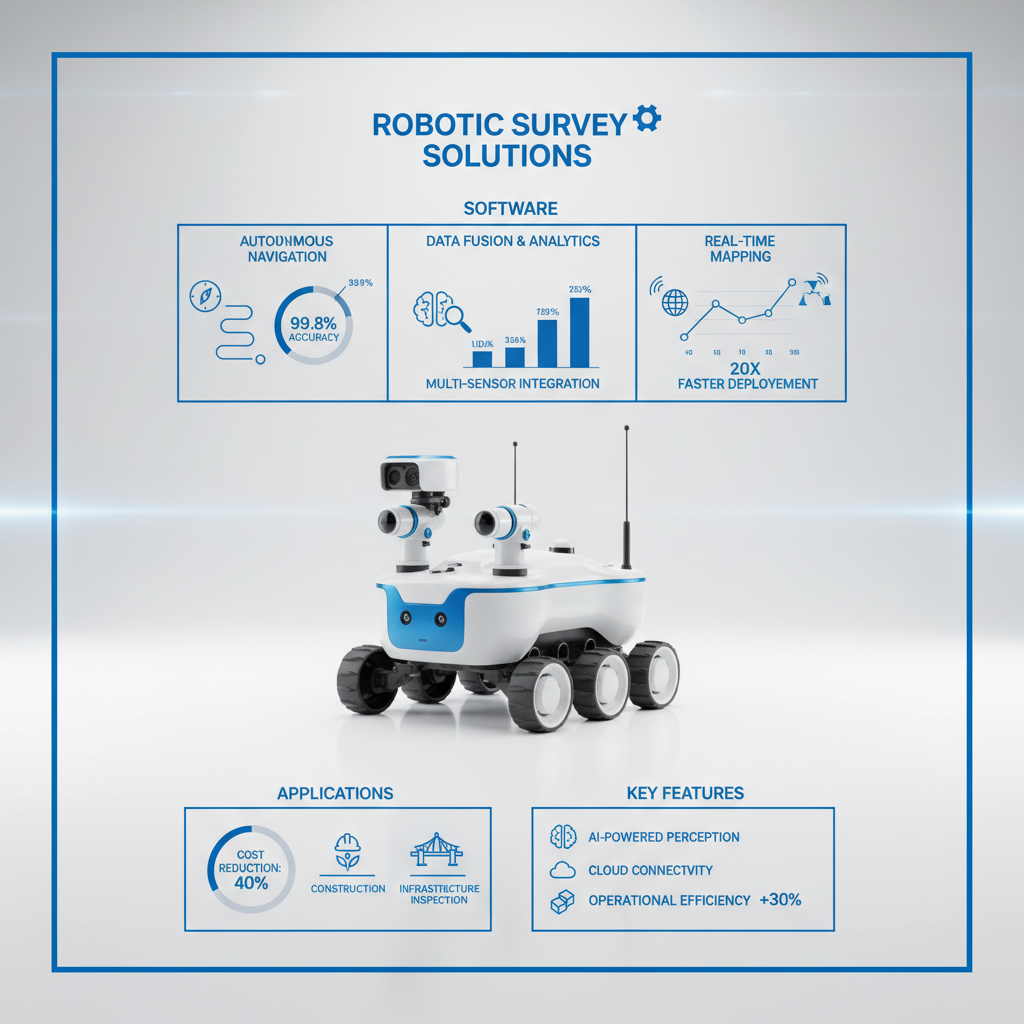
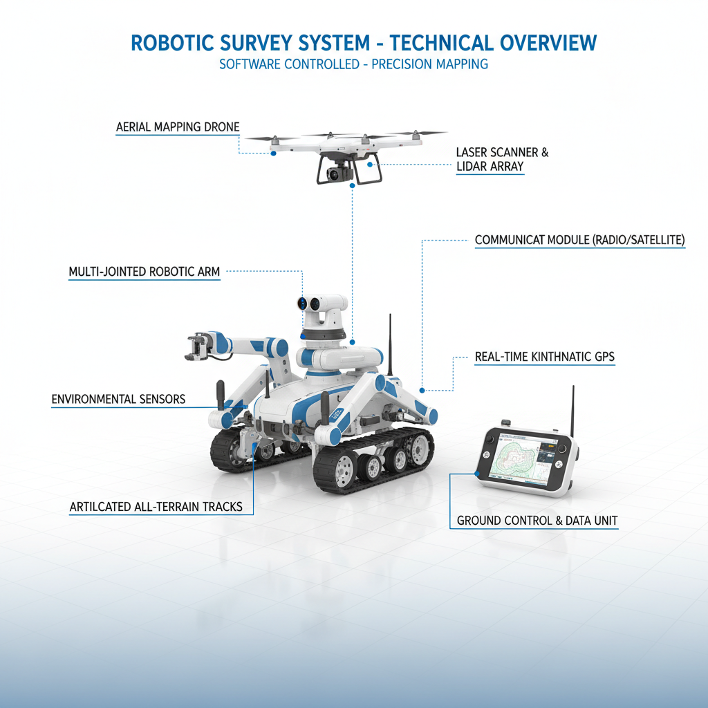
At its core, a robotic survey equipment product is an autonomous or semi-autonomous system designed to capture precise spatial data without the need for a constant human operator at the measurement point. These systems typically combine high-precision GNSS receivers, LiDAR scanners, and IMU (Inertial Measurement Unit) sensors, all controlled by an onboard intelligence system that manages navigation and data logging.
Unlike traditional tools, these robotic solutions are built to interact with the environment. Whether it is a rover navigating a cornfield for precision agriculture or a drone mapping a disaster zone, the "robotic" element refers to the system's ability to execute a predefined survey path while making real-time adjustments to maintain accuracy and avoid obstacles.
In the context of modern humanitarian and industrial needs, these tools are indispensable. They allow for the rapid mapping of inaccessible regions—such as landslide-affected areas or deep industrial mines—providing critical data that allows engineers to design safety interventions without putting human lives at risk.
Core Components of Autonomous Survey Systems
The effectiveness of a robotic survey equipment product depends heavily on its sensor fusion capabilities. By combining data from Multiple GNSS constellations (like GPS, GLONASS, and BeiDou) with high-frequency IMUs, the system can maintain centimeter-level accuracy even when satellite signals are partially obstructed by canopy or urban canyons.
Durability and environmental sealing are equally critical. A professional-grade robotic survey equipment product must be IP67 or IP68 rated, ensuring that fine dust in mining sites or heavy rain in tropical agriculture zones does not compromise the internal circuitry or the precision of the optical sensors.
Finally, the software ecosystem serves as the brain of the operation. From cloud-based data collectors to autonomous path-planning algorithms, the ability to export survey data directly into BIM (Building Information Modeling) or GIS (Geographic Information Systems) software transforms raw coordinates into actionable commercial intelligence.
Performance Benchmarks and Scalability
When evaluating a robotic survey equipment product, industry experts look at "Time to First Fix" (TTFF) and the stability of the RTK (Real-Time Kinematic) link. Scalability is measured by how easily a single operator can manage a fleet of robotic rovers or UAVs to cover vast acreages, moving from localized site surveys to regional mapping efforts without a linear increase in manpower.
The transition from manual to robotic surveying represents a shift from "point-based" sampling to "area-based" coverage. This allows for a much higher density of data points, which is essential for creating high-resolution Digital Elevation Models (DEMs) used in precision drainage and soil analysis.
Efficiency Comparison of Robotic Survey Equipment Product Methods
Real-World Global Applications
In the realm of precision agriculture, the robotic survey equipment product is used to create variable-rate application maps. By autonomously scanning soil moisture and nutrient levels across thousands of hectares, farmers can apply fertilizers only where needed, significantly reducing chemical runoff into local water systems and lowering operational costs.
In industrial zones, particularly within mining and quarrying, these robots are deployed for volumetric analysis. Instead of technicians climbing dangerous stockpiles, a robotic system can scan the entire volume of material in minutes, providing an exact tonnage calculation that is critical for supply chain logistics and financial auditing.
Long-Term Value and Operational Advantages
The primary logical advantage of investing in a robotic survey equipment product is the drastic reduction in "per-point" data cost. While the initial capital expenditure is higher than manual tools, the elimination of multiple field crews and the reduction of data processing time lead to a rapid Return on Investment (ROI), often within the first 12-18 months of deployment.
From a safety perspective, the emotional and social value is immense. By removing humans from hazardous environments—such as unstable slopes or chemically contaminated sites—companies demonstrate a commitment to worker dignity and safety. This reduces insurance premiums and enhances the company's reputation as an innovative, employee-centric organization.
Furthermore, the reliability of robotic data fosters deeper trust between contractors and clients. When a survey is generated by an autonomous system with a digital audit trail, the possibility of "guessed" measurements or manual entry errors is eliminated, leading to fewer disputes during the construction and handover phases of a project.
Future Innovations in Robotic Surveying
The next frontier for the robotic survey equipment product lies in the integration of AI-driven "Edge Computing." Future systems will not just collect data but analyze it on-the-fly, allowing the robot to decide to re-scan an area of interest if it detects a topographical anomaly, without waiting for a human to review the data in the office.
Sustainability is also driving innovation, with a move toward solar-powered autonomous rovers capable of "persistent surveying." These systems could live in the field, waking up periodically to monitor structural shifts in dams or bridges, providing a continuous stream of safety data that could prevent catastrophic failures through early warning signs.
Finally, the convergence of 5G connectivity and "Digital Twin" technology will allow robotic survey equipment to update a virtual 3D model of a city or farm in real-time. This seamless loop between the physical world and the digital replica will enable unprecedented levels of automation in urban planning and resource management.
Comparative Analysis of Robotic Surveying Technologies
| Technology Type |
Precision Level |
Deployment Speed |
Operating Cost |
| Autonomous Ground Rover |
Centimeter (RTK) |
Medium |
Low |
| Surveying UAV (Drone) |
Decimeter to CM |
Very High |
Medium |
| Robotic Total Station |
Millimeter |
Low |
High |
| SLAM-based Mobile Mapper |
Centimeter |
High |
Medium |
| Autonomous Submersible |
Decimeter |
Low |
Very High |
| Hybrid Rover-UAV System |
Centimeter |
High |
Medium |
FAQS
While a standard GNSS rover requires a human to carry the pole to every single point of interest, a robotic survey equipment product can navigate autonomously between points. It integrates path-planning software and obstacle avoidance sensors, allowing it to collect thousands of points across a landscape without constant human intervention, thereby increasing speed and reducing personnel costs.
Yes, high-end robotic survey products utilize "sensor fusion." When the GNSS signal is weakened by foliage, the system relies on a high-precision IMU and sometimes SLAM (Simultaneous Localization and Mapping) via LiDAR. This allows the robot to "dead reckon" its position with extreme accuracy until a clear satellite lock is re-established.
Most firms see a full return on investment within 12 to 24 months. This is achieved through a combination of reducing field crew sizes (often from 3 people to 1), eliminating travel time for manual point-checking, and drastically reducing the time spent in the office cleaning and processing manual data entries.
While the robots handle the physical measurement, operators need training in mission planning and data management. Modern interfaces are designed to be intuitive (similar to tablet apps), but understanding the underlying GNSS corrections (RTK/PPK) is essential to ensure the data collected is accurate and reliable.
Absolutely. Professional robotic survey products are designed for interoperability. They typically export data in standard formats such as .CSV, .DXF, or .LAS, which can be imported directly into ArcGIS, AutoCAD, or QGIS, ensuring a seamless workflow from the field to the final map.
Depending on the product, they use different modalities. Ground rovers often feature high-torque brushless motors and all-terrain treads or wheels. For truly impassable terrain, UAV-based robotic survey products are used to capture data from the air, combining photogrammetry with LiDAR to "see through" vegetation to the ground surface.
Conclusion
The integration of a robotic survey equipment product into professional workflows represents more than just a technical upgrade; it is a fundamental shift toward a more efficient, safe, and data-driven approach to spatial measurement. By combining the precision of GNSS with the autonomy of robotics, industries can now capture an unprecedented density of information while minimizing human risk and operational overhead.
Looking forward, as AI and 5G continue to mature, these systems will evolve from simple data collectors into intelligent site managers capable of real-time analysis and autonomous decision-making. For businesses aiming to remain competitive in an increasingly automated world, adopting these robotic solutions today is the most effective way to ensure future scalability and operational excellence. Visit our website: www.nctnav.com