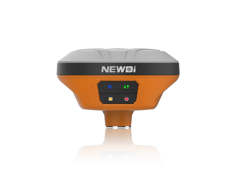

The Geodetic GNSS N702 suits survey teams that need multi-constellation tracking, RTK and static workflows, remote data handling, and field protection. Use its communication, storage, data-format, and environmental specifications to check fit before requesting a quotation.

Correction and positioning workflow: confirm that the receiver's multi-constellation tracking, RTK and static accuracy figures, raw-data update rate, and cold-start time fit the project's real-time and post-processing work.
System compatibility and data handling: match 4G, LoRa, TCP, UDP, MQTT, CMR, RTCM, RINEX, FTP, serial, and UHF connections with the existing correction source, software, antenna, and data-retrieval system.
Field installation conditions: check the IP67 rating, operating and storage temperature ranges, condensation handling, shock resistance, dimensions, and weight against the intended site and mounting arrangement.
Survey buyers looking to buy high precision gnss receiver factory equipment should start with the field workflow, correction link, and data-handling plan. The Geodetic GNSS N702 is suited to projects that use RTK positioning, static post-processing, or a receiver as part of an RTK network.
Match the receiver to the survey workflow
The N702 tracks GPS, GLONASS, Galileo, BeiDou, QZSS, and SBAS signals with 72 channels. Its RTK accuracy is specified as 10 mm + 1 ppm horizontally and 15 mm + 1 ppm vertically. For static post-processing, the specified accuracy is 2.5 mm + 0.5 ppm horizontally and 5 mm + 0.5 ppm vertically.
That combination fits a team moving between real-time rover support and static data collection. The receiver can update raw data at up to 10 Hz, with a listed cold-start time of 30 seconds. Before ordering, map these modes to the correction source, rover equipment, and processing software used by your field crews.
Check the data and communication path
A receiver becomes easier to deploy when its data path matches the project system. The N702 includes a 4G module and LoRa radio, with TCP, UDP, and MQTT network protocols. It supports CMR, RTCM 2.x, RTCM 3.x, and Full Star data formats, while static data can be saved in RINEX 2.11 and 3.02.
The unit has 64 GB of internal storage and supports up to 256 GB of external storage. It can record up to eight separate data sessions and provides an embedded FTP server or FTP push to a remote site. This suits monitoring or reference-station work where crews need separate sessions and a planned retrieval route.
For a field setup, check the complete chain before purchase: correction source, radio or network link, port connection, FTP destination, and the software that will open the RINEX files. The N702 has one serial port for data download, charging, and firmware updates, plus one TNC female UHF antenna port.
Account for installation conditions
The N702 is rated IP67 for dust and water resistance. Its listed operating range is -40°C to +85°C, and its storage range is -55°C to +95°C. The specification also lists resistance to 100% condensation, a 2 m drop survival claim, and GJB150.16-2009 and MIL-STD-810 shock-resistance grades.
These details suit installations and survey work exposed to dust, moisture, temperature swings, or occasional handling impacts. Picture a reference receiver installed at a remote site while raw sessions are sent through FTP push, or a survey crew switching between RTK work and static logging during a long project. In both cases, match the receiver's environmental range and connection layout to the actual enclosure, mounting point, antenna cable, and power arrangement.
Who should choose the N702
Choose the Geodetic GNSS N702 when your project needs multi-constellation tracking, RTK and static data workflows, several independent logging sessions, or remote transfer through FTP, TCP, UDP, or MQTT. Its 0.9 kg body and 160 mm diameter by 115 mm height should also be checked against the mounting space and transport cases used by your team.
The N702 is a less direct fit when your workflow depends on a different correction protocol, a different file format, a different antenna connection, or a smaller installation envelope. Send the supplier your rover and base-station arrangement, correction protocols, required file formats, antenna connection, mounting dimensions, and quantity so the quotation can be checked against the working system.
The people

About the author
The company
Shanghai Newdi Navigation Technology Co.,Ltd
Shanghai Newdi Navigation Technology Company Limited (NEWDI) was established in 2016. NEWDI is engaged in providing high-precision surveying and mapping instrument. Main product is GNSS receiver, total station, level, drones, 3D scanner, echo sounder and USV. Our products is professional for land survey, construction, marine survey, GIS and mobile mapping. NEWDI gains a 100% annual growth rate in past 3 years.…
About Us ↗Visit company website ↗Your next step
Bring your brief. Start a useful conversation.
Use case, specification, quantity and delivery window: make the next conversation specific.