

Contact Us
Pocket-IMU GNSS Receiver
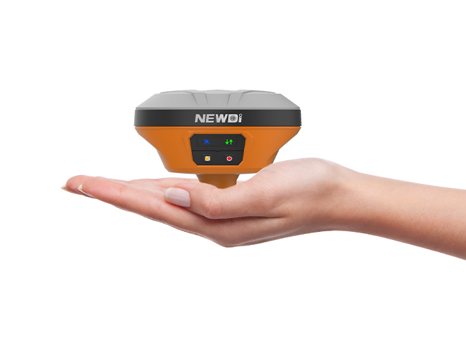
THE ULTIMATE POCKET IMU-RTK GNSS RECEIVER
Extremely rugged to cope with challenging environments. The E93's magnesium alloy design makes it one of the lightest receivers in its class: only 0.73 kg including battery. It is more than 40% lighter than a typical GNSS receiver, making it more convenient to carry, use and operate without fatigue.
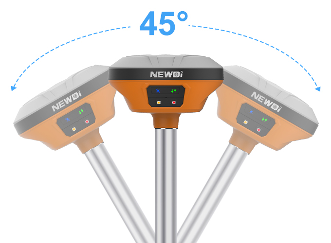
THE POWER of GNSS + IMU TECHNOLOGY
The E93 compensates for up to 45 ° tilt of the survey range pole, eliminating the challenges associated with surveying concealed or unsafe points to reach. It increases the efficiency of point measurements by 20% and stakeout surveys by up to 30%.
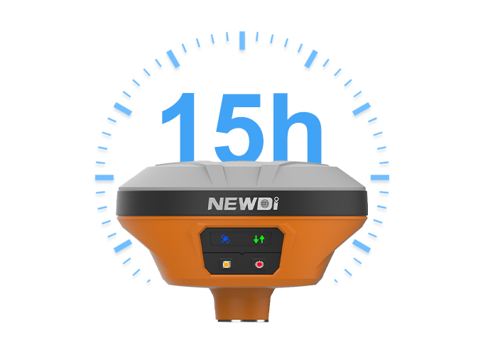
Get full power with 15 hours of battery operation
The integrated high-capacity intelligent Li-ion battery provides up to 15 hours operation in the field. Full-day projects can be easily completed without worrying about a power outage. The built-in USB-C is extremely convenient for charging the i73, using standard smartphone chargers or external power banks
Performance Specification
Performance Specification
GNSS Characteristics
• 624 channels with all in view simultaneously tracked
satellite signals
– GPS: L1, L2, L5
– GLONASS: L1, L2
– BDS: B1, B2, B3
– Galileo: E1, E5a, E5b
– QZSS: L1, L2, L5
– SBAS: L1
• Advanced multipath mitigation technology
• Low noise carrier phase measurement
GNSS Accuracies (1)
• Real Time Kinematics (RTK):
– Horizontal: 8 mm + 1 ppm RMS
– Vertical: 15 mm + 1 ppm RMS
– Initialization Time: < 10 s
– Initialization Reliability: > 99.9%
• Post-processing Static:(Static)
– Horizontal: 3 mm + 1 ppm RMS
– Vertical: 5 mm + 1 ppm RMS
• Post-processing Kinematics(PPK)
– Horizontal: 3 mm + 1 ppm RMS
– Vertical: 5 mm + 1 ppm RMS
• Code Differential
– Horizontal: 0.4m RMS
– Vertical: 0.8m RMS
• Autonomous
– Horizontal: 1m RMS
– Vertical: 1.5m RMS
• Time to first fix
– Cold start: < 45 s
– Hot start: < 30 s
– Signal re-acquisition: < 2 s
• RTK tilt-compensated
– Additional horizontal pole-tilt uncertainty typically less than 10mm +0.7mm/° tilt
• Raw data updating: up to 10Hz
Hardware
• Size: 119mm×119mm×85mm
(4.7 in x 4.7 in x 3.3 in)
• Weight: 0.73 kg with battery (1.61 lb)
• Environment
– Operating: -45°C to +75°C (-49°F to +167°F)
– Storage: -55°C to +85°C (-67°F to +185°F)
• Humidity: 100% condensation
• Dust and Water Proof: IP67
• Shock and Vibration: Survive a 2-meter pole drop
•Tilt sensor: Calibration-free IMU for pole-tilt compensation.
Immune to magnetic disturbance
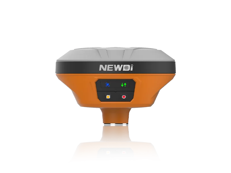
•Front panel: 4 LED indicates
Communications
• Bluetooth: BT 4.0
• Wi-Fi: 802.11 b/g/n, access mode
• UHF Radio:
–Protected TNC Female
– Standard Internal Rx: 430 MHz to 470 MHz
–Link rate: 9600/bps/19200/bps
–Protocol: CHC, Transparent, TT450
– External Tx DL6: 5 W to 28 W adjustable
• Data formats:
– CMR input and output
– RTCM2.x, RTCM3.x input and output, NEMA 0183 output
–HCN, HRC RINEX 2.11, 3.02
• Ports:
– 1 x USB type-C port(data download, charging, firmware update)
–1 x UHF antenna port(TNC female)
• Data Storage: 8 GB high speed memory
• Others: NFC
Electrical
• Power Consumption: 4W (depending on receiver configuration)
• Li-ion Battery Capacity: Built in non-removable battery
6800mAh, 7.4V
• Operating Time (2):
–RTK Rover: 12h
–Static: up to 15h
Software (Standard)
• Geofix Android field data collection software
• 624 channels with all in view simultaneously tracked
satellite signals
– GPS: L1, L2, L5
– GLONASS: L1, L2
– BDS: B1, B2, B3
– Galileo: E1, E5a, E5b
– QZSS: L1, L2, L5
– SBAS: L1
• Advanced multipath mitigation technology
• Low noise carrier phase measurement
GNSS Accuracies (1)
• Real Time Kinematics (RTK):
– Horizontal: 8 mm + 1 ppm RMS
– Vertical: 15 mm + 1 ppm RMS
– Initialization Time: < 10 s
– Initialization Reliability: > 99.9%
• Post-processing Static:(Static)
– Horizontal: 3 mm + 1 ppm RMS
– Vertical: 5 mm + 1 ppm RMS
• Post-processing Kinematics(PPK)
– Horizontal: 3 mm + 1 ppm RMS
– Vertical: 5 mm + 1 ppm RMS
• Code Differential
– Horizontal: 0.4m RMS
– Vertical: 0.8m RMS
• Autonomous
– Horizontal: 1m RMS
– Vertical: 1.5m RMS
• Time to first fix
– Cold start: < 45 s
– Hot start: < 30 s
– Signal re-acquisition: < 2 s
• RTK tilt-compensated
– Additional horizontal pole-tilt uncertainty typically less than 10mm +0.7mm/° tilt
• Raw data updating: up to 10Hz
Hardware
• Size: 119mm×119mm×85mm
(4.7 in x 4.7 in x 3.3 in)
• Weight: 0.73 kg with battery (1.61 lb)
• Environment
– Operating: -45°C to +75°C (-49°F to +167°F)
– Storage: -55°C to +85°C (-67°F to +185°F)
• Humidity: 100% condensation
• Dust and Water Proof: IP67
• Shock and Vibration: Survive a 2-meter pole drop
•Tilt sensor: Calibration-free IMU for pole-tilt compensation.
Immune to magnetic disturbance
•Front panel: 4 LED indicates
Communications
• Bluetooth: BT 4.0
• Wi-Fi: 802.11 b/g/n, access mode
• UHF Radio:
–Protected TNC Female
– Standard Internal Rx: 430 MHz to 470 MHz
–Link rate: 9600/bps/19200/bps
–Protocol: CHC, Transparent, TT450
– External Tx DL6: 5 W to 28 W adjustable
• Data formats:
– CMR input and output
– RTCM2.x, RTCM3.x input and output, NEMA 0183 output
–HCN, HRC RINEX 2.11, 3.02
• Ports:
– 1 x USB type-C port(data download, charging, firmware update)
–1 x UHF antenna port(TNC female)
• Data Storage: 8 GB high speed memory
• Others: NFC
Electrical
• Power Consumption: 4W (depending on receiver configuration)
• Li-ion Battery Capacity: Built in non-removable battery
6800mAh, 7.4V
• Operating Time (2):
–RTK Rover: 12h
–Static: up to 15h
Software (Standard)
• Geofix Android field data collection software


