
CE Certification Pilotnav GNSS RTK Base and Rover Pricelist Guide
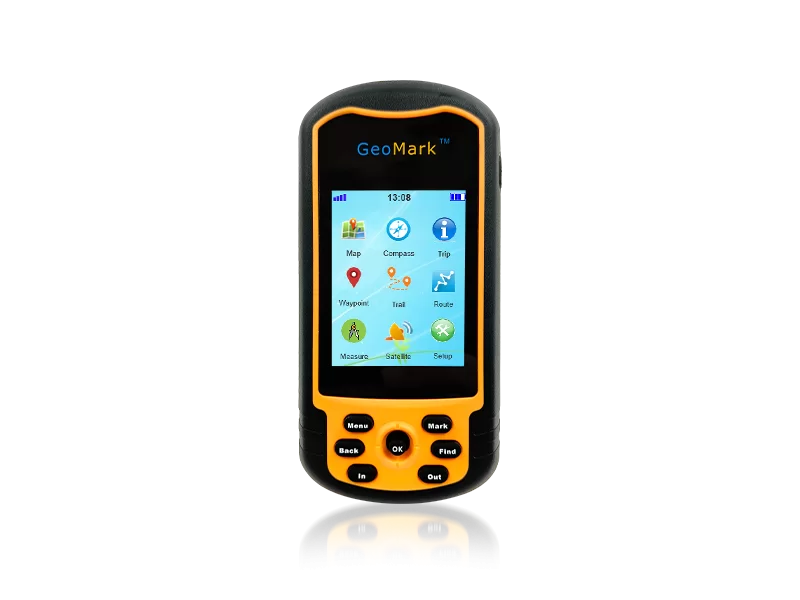
For field professionals operating in remote or rugged environments, the balance between portability and spatial accuracy is often a critical challenge. The M20 Handheld GPS addresses this need by integrating a high-sensitivity GNSS sensor suite with a ruggedized chassis, specifically engineered for land assessment, resource planning, and strategic outdoor navigation. Unlike consumer-grade devices, this instrument is built to maintain signal stability in challenging terrains, providing the dependable data required for professional surveying and mapping tasks.
By leveraging multi-constellation support, the M20 allows operators to record complex travel trajectories and mark critical waypoints with precision. Whether the objective is calculating precise land areas for property boundaries or conducting wilderness surveys, this device streamlines the data collection process. For organizations evaluating a ce certification pilotnav gnss rtk base and rover pricelist, the M20 serves as a versatile, cost-effective handheld complement to high-precision RTK networks, ensuring that field teams remain mobile without sacrificing operational efficiency.

Technical Architecture of the M20 Multi-Constellation GNSS System
The M20 Handheld GPS is engineered around a dual-system sensor core, integrating GPS L1 and BDS B1 frequencies. This multi-constellation approach significantly reduces the time to first fix (TTFF) and enhances positioning reliability in areas where satellite visibility may be obstructed by canopy or terrain. To further refine spatial data, the device supports a comprehensive array of SBAS (Satellite-Based Augmentation Systems), including WAAS, EGNOS, MSAS, and GAGAN, which provide critical corrections to the raw satellite signals.
Physical durability is a cornerstone of the M20's design. The ruggedized chassis is rated for operation in extreme temperatures ranging from -20°C to 60°C, ensuring consistent performance from arctic tundra to tropical rainforests. The integration of a 3-axis e-compass and an altimeter/barometer allows the user to capture a three-dimensional environmental snapshot, providing more than just coordinates but a full spatial context of the survey site.
- Signal Stability: Optimized antenna design for high-sensitivity reception in dense environments.
- Data Expansion: Micro SD card slot supporting up to 32GB for high-resolution base maps.
- Interface: Industrial-grade buttons and rocky keys for operation with gloves in the field.

Operational Applications in Land Assessment and Resource Mapping
In professional land assessment, the ability to calculate enclosed areas accurately is paramount. The M20 facilitates this through a dedicated area calculation function; by recording a series of waypoints around the perimeter of a plot, the device automatically computes the total area. This eliminates the need for manual geometric calculations and reduces the risk of human error during the initial site survey phase.
Beyond area measurement, the dynamic track recording feature is indispensable for route analysis and safety. Field professionals can retain precise movement trajectories, which are essential for reviewing trip history or ensuring the safety of personnel in uncharted wilderness. The 2.4-inch QVGA display provides clear visualization of these coordinates and map overlays, ensuring that navigation remains intuitive even under varying outdoor lighting conditions.
Data management is handled through a streamlined workflow. Once field data is collected, it can be exported via the Mini USB 2.0 interface for seamless integration into office-based GIS software. This transition from field collection to digital processing is what allows survey teams to increase their daily output and reduce the overall project timeline.
Comparing Digital Handheld GNSS vs. Traditional Surveying Methods
The shift from traditional manual logging to digital GNSS instruments like the M20 represents a significant leap in operational speed. Traditional methods often rely on manual sketches and physical measurements, which are prone to transcription errors and require significant manpower. In contrast, the M20 allows a single operator to capture high-precision coordinates and area data digitally, which can be instantly exported for analysis.
While high-end RTK systems provide centimeter-level accuracy, the M20's 1-3 meter accuracy is often more than sufficient for broad land assessment, boundary marking, and navigation. The primary value lies in the portability and speed of deployment. A surveyor can move across vast distances quickly, marking waypoints and recording tracks without the need for heavy tripod setups or complex base-station configurations for every single point.
When considering the investment return, the reduction in man-hours per hectare surveyed is the most impactful metric. The ability to use preloaded custom maps via SD cards further enhances this efficiency, as operators can navigate directly to specific coordinates of interest without relying on outdated paper maps.
M20 Handheld GPS Performance and Specification Matrix
| Feature Dimension | Technical Specification | Operational Impact | Industry Standard |
|---|---|---|---|
| Positioning Accuracy | 1-3 Meters | Reliable for land assessment | Professional Grade |
| Satellite Systems | GPS L1 / BDS B1 / SBAS | Enhanced signal acquisition | Multi-Constellation |
| Operating Temp | -20°C to 60°C | Extreme environment ready | Industrial Rugged |
| Data Storage | Micro SD (up to 32GB) | High-capacity map support | Expandable |
| Interface/Power | USB 2.0 / 2x AA Batteries | Easy power replacement | Field Versatile |
Selecting the Right GNSS Tool for Your Surveying Workflow
Choosing between different GNSS tiers requires an understanding of the project's precision requirements. If the goal is millimetric construction alignment, an RTK rover is necessary. However, for resource planning, forest management, or strategic navigation, the M20 offers a superior balance of cost and utility. Buyers should evaluate the need for real-time correction versus the need for rapid, portable data gathering across expansive terrains.
A key consideration for procurement managers is the ecosystem of support. NEWDI provides a professional support team and a dedicated repair center to ensure that instruments are returned to service quickly. In the surveying industry, downtime during a field campaign can be extremely costly; therefore, having a supplier with in-stock products and a robust technical support framework is a critical risk-mitigation strategy.
Furthermore, the compatibility of the device with existing GIS workflows should be verified. The M20's ability to export data via USB ensures that coordinates can be converted into standard formats used by most mapping software, allowing for a seamless transition from the field to the final report.
Future Trends in Portable Spatial Data Collection
The trend in handheld GNSS technology is moving toward greater integration of sensor arrays. We are seeing a shift where simple coordinate capture is being replaced by comprehensive environmental data logging. The inclusion of altimeters and electronic compasses in the M20 is a precursor to this trend, allowing for more detailed 3D modeling of outdoor environments.
As satellite constellations like BeiDou and GPS continue to evolve, the precision of handheld devices is expected to improve further. The integration of more advanced SBAS corrections will likely narrow the gap between handheld instruments and more expensive stationary equipment, making professional-grade spatial data accessible to a wider range of field professionals.
For companies looking to modernize their field kits, the recommendation is to adopt a tiered approach: utilizing high-precision RTK for critical benchmarks and rugged handhelds like the M20 for general exploration and area mapping. This hybrid strategy optimizes both the budget and the operational speed of the survey team.
Frequently Asked Questions About M20 GNSS Technology
What is the accuracy range of the M20 Handheld GPS?
The M20 provides a positioning accuracy of 1-3 meters, utilizing a combination of GPS L1 and BDS B1 sensors to ensure reliable data in various terrains.
Can I upload my own custom maps to the device?
Yes, the M20 supports Micro SD cards up to 32GB, allowing users to add detailed custom maps for specific regional navigation.
How does the area calculation function work?
By marking the perimeter of a plot of land through waypoint recording, the device automatically calculates the enclosed area, ideal for land assessment.
Is the M20 suitable for extreme temperature environments?
Absolutely. The device is rated for operating temperatures between -20°C and 60°C, making it durable for both arctic and tropical field work.
Which satellite systems does the M20 support?
The M20 supports GPS L1 and BDS B1, and is compatible with SBAS systems including WAAS, EGNOS, MSAS, and GAGAN for enhanced signal correction.
How is data transferred from the M20 to a computer?
Data can be exported using the Mini USB 2.0 interface, allowing for quick transfer and conversion of coordinates and tracks for further analysis.
Technical References and Industry Standards
- Official U.S. Government GPS Information
- BeiDou Navigation Satellite System Overview
- NMEA Standard for Marine Electronics and GNSS
- European GNSS Agency (EGNOS) Technical Standards
Ready to enhance your field precision with M20 GNSS technology? Contact NEWDI today for detailed specifications and procurement options to optimize your surveying workflow.
Related High-Precision Surveying Solutions