
QUESTIONS & ANSWERS
M20 Handheld GPS Instruments FAQ: Compatibility, Corrections and Support Questions
This FAQ answers the most common questions buyers and field teams ask about the M20 Handheld GPS Precision GNSS Instrument — one of Shanghai Newdi Navigation Technology Co.,Ltd's handheld GPS instruments — covering satellite compatibility, SBAS correction support, custom map loading, power supply options, data transfer, environmental ratings, and supported field functions.

M20 Handheld GPS Precision GNSS Instrument FAQ: Compatibility, Corrections and Support Questions
The M20 Handheld GPS Precision GNSS Instrument from Shanghai Newdi Navigation Technology Co.,Ltd is a professional-grade handheld GPS GNSS device engineered for land assessment, resource planning, and outdoor navigation in demanding environments. The questions below address real pre-purchase and operational concerns — from which satellite systems the M20 supports to how data is transferred back to the office.
Compatibility & Signal Reception
Which satellite constellations does the M20 support?
The M20 receives signals from GPS L1 and BDS B1 (BeiDou). It also supports the SBAS augmentation services WAAS (North America), EGNOS (Europe), MSAS (Japan), and GAGAN (India), helping users in those regions improve autonomous accuracy without an external RTK base station.
Does the M20 support RTK corrections?
The M20 lists GPS L1 and BDS B1 sensors with a position accuracy of 1–3 metres and SBAS augmentation.
What SBAS systems does the M20 work with?
The M20 is compatible with WAAS, EGNOS, MSAS, and GAGAN. SBAS improves autonomous single-point accuracy by applying satellite-broadcast correction data, which is useful for land and GIS work where 1–3 m positional accuracy is acceptable.
Accuracy & Positioning
What positioning accuracy does the M20 deliver?
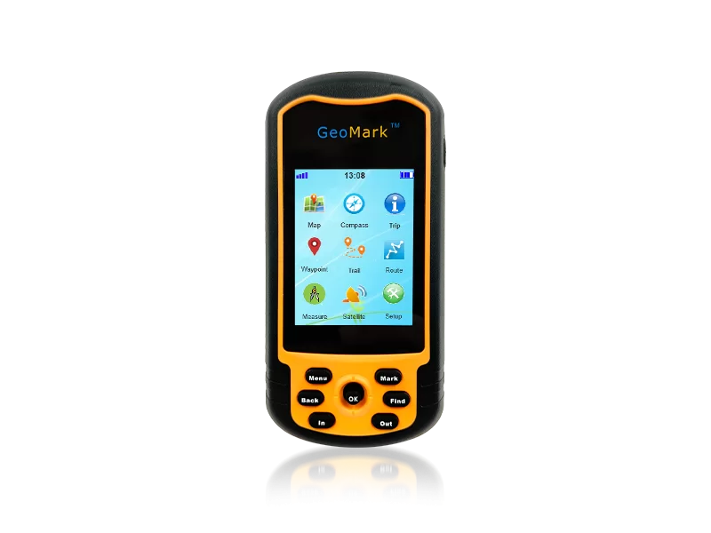
The M20 achieves a position accuracy of 1–3 metres, using a combination of GPS L1 and BDS B1 sensors with a high-sensitivity patch antenna. This accuracy level supports professional land assessment, area calculation, waypoint marking, and route recording tasks.
How does the antenna improve signal quality?
The M20 uses a high-sensitivity patch antenna, which is optimised for compact handheld GPS instruments and provides stable signal reception across varied terrains and challenging outdoor environments.
Maps, Storage & Data
Can I load custom or detailed maps onto the M20?
Yes. The M20 includes preloaded base maps and supports the addition of detailed maps via a Micro SD card (up to 32 GB). Users can load regional or task-specific map data to the SD card and the device will display them through its mapping interface, enabling intuitive visual navigation in the field.
How much storage does the M20 have, and what card does it use?
The M20 accepts Micro SD cards up to 32 GB. This storage is used for both addable detailed maps and survey data including waypoints, tracks, and routes.
How is field data transferred to a computer?
The M20 connects to a computer via Mini USB 2.0. The built-in data transfer and conversion function allows field data — waypoints, routes, and track logs — to be exported for office processing.
Power Supply
What batteries does the M20 use?
The M20 is powered by 2 × AA batteries as its standard power source. An optional Li-ion battery and AC adapter are also listed as optional accessories, offering flexibility for extended field deployments.
Is the M20 suitable for extended field work on standard AA cells?
The M20 runs on readily available AA batteries, making it practical for remote fieldwork where specialised battery packs may be difficult to source. The optional Li-ion battery is available as an accessory for users who prefer rechargeable power.
Display & Interface
What display does the M20 have?
The M20 features a 2.4-inch QVGA display. This screen provides clear visibility of maps, coordinates, and navigation data under various outdoor lighting conditions.
How is the M20 operated in the field?
Input is via physical button and Rocky key controls, which are practical for gloved hands or wet-weather operation. The Mini USB 2.0 port handles data transfer.
Environmental Ratings & Physical Specifications
What temperatures can the M20 operate in?
The M20 has an operating temperature range of −20 °C to 60 °C and a storage temperature range of −30 °C to 70 °C, making it suitable for cold-region surveys and hot-climate fieldwork.
What are the physical dimensions of the M20?
The device measures 115 × 59 × 33 mm, a compact form factor for a professional-grade handheld GPS GNSS instrument intended for field carry.
Core Field Functions
What field functions does the M20 support?
The M20 supports waypoint recording, route recording, track recording, area and distance measurement, outdoor navigation, base map display, addable detail maps, a 3-axis e-compass, an altimeter/barometer, user-defined coordinate systems, and data transfer and conversion. These functions cover common land survey, GIS, and outdoor activity scenarios.
Does the M20 include an e-compass and altimeter?
Yes. The sensor suite includes a 3-axis e-compass and a combined altimeter/barometer, providing heading and elevation data to complement GNSS positioning during field operations.
In the Box & Optional Accessories
What is included in the box with the M20?
Standard package contents are: one M20 device, one manual, and one lanyard.
What optional accessories are available for the M20?
Optional accessories listed for the M20 include a Mini USB cable, an AC adapter, a Li-ion battery, and a Micro SD card.
For technical support or order enquiries regarding the M20 handheld GPS instruments, contact Shanghai Newdi Navigation Technology Co.,Ltd directly.
THE PEOPLE

About the author
THE COMPANY
Shanghai Newdi Navigation Technology Co.,Ltd
Shanghai Newdi Navigation Technology Company Limited (NEWDI) was established in 2016. NEWDI is engaged in providing high-precision surveying and mapping instrument. Main product is GNSS receiver, total station, level, drones, 3D scanner, echo sounder and USV. Our products is professional for land survey, construction, marine survey, GIS and mobile mapping.
NEWDI gains a 100% annual growth rate in past 3 years.…
YOUR NEXT STEP
Bring your brief. Start a useful conversation.
Use case, specification, quantity and delivery window: make the next conversation specific.